Discover Dorëzi Castle- the oldest urban civilisation in Tirana
Dorezi- Discover the forgotten fortress that once controlled the ancient road from Dyrrhachium toward the valleys of the Shkumbin River and the interior Balkans.
Dorezi Castle is the oldest castle in the Tirana Region. Located about 20 km south-west of Tirana, it lies about 5 km east of Peza. This castle belongs to the Bronze era, XIV- XIII centuries BC. The first archaeological work was carried out in 1951. Its ruins cover a high range of hills detached from the mountains at an altitude of 479 m above sea level.
The ancient Castle of Dorëzi was first documented by the Albanian archaeologist Hasan Ceka in 1948, when he described its fortification walls and dated them to an early period, before the 5th century BC. Because of the primitive appearance of the masonry, later scholars such as Selim Islami and Muzafer Korkuti suggested that the walls belonged to the Early Iron Age.
Later, Neritan Ceka, based on an analysis of construction techniques and early urban planning features, proposed that the settlement originated during the 7th–6th centuries BC as a proto-urban center.
However, the information panel installed at the site by the local municipality suggests an even earlier origin. According to this interpretation, the settlement may have been inhabited since the Bronze Age (14th–13th centuries BC), when it was known as Qyteza—meaning “small city.” The site lies at approximately 476 meters above sea level.
If this early dating is confirmed, Dorëzi would represent the earliest urban settlement in the region of Tirana, inhabited continuously from the Bronze Age until Late Antiquity, when the Roman presence reshaped the region
A Strategic Location Above the Valleys
The castle occupies a naturally defensive hilltop position. Its northern side is protected by steep rocky cliffs, which made artificial fortification unnecessary on that side, while the southern side was enclosed by defensive walls.
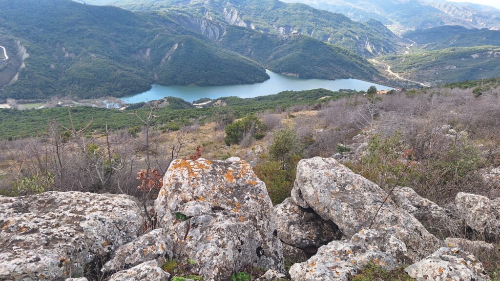
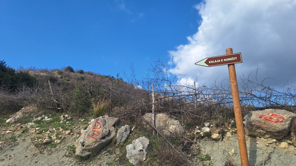
To reach Dorëzi Castle today, visitors start from the center of the village of Peza e Madhe and follow the road leading toward the Fjolla reservoir. The fortress rises dramatically on white cliffs to the northeast, above a small picturesque lake hidden behind a dense forest belt.
After about 2.4 kilometers along the valley, the route reaches Qafa e Dorëzit, above the village of the same name. From there, the castle walls can be reached by walking approximately 600 meters northwest.
From the summit, the view opens over the valleys of the Erzen and Peza rivers, where the nearby Castle of Preza dominates the landscape. To the east, the horizon is defined by the mountains of Mount Dajti and the Krraba Mountains.
A parallel ridge extends from Dorëzi toward the Vrap Castle through the ridge of Cacabeza and eventually descends toward the valley of the Shkumbin River between Peqin and Papër.
In antiquity, this corridor formed a natural route connecting Dyrrhachium with the middle Shkumbin valley and further east toward Macedonia. Dorëzi Castle likely functioned as a strategic checkpoint along this important inland route, particularly during the 6th–1st centuries BC before the Roman road network was fully developed.
Later, when the Roman Via Egnatia became the main artery across the Balkans, Dorëzi gradually lost its importance. Yet the fortress regained defensive value again in Late Antiquity, when the Roman road system was disrupted by barbarian incursions.
The Fortified Hill
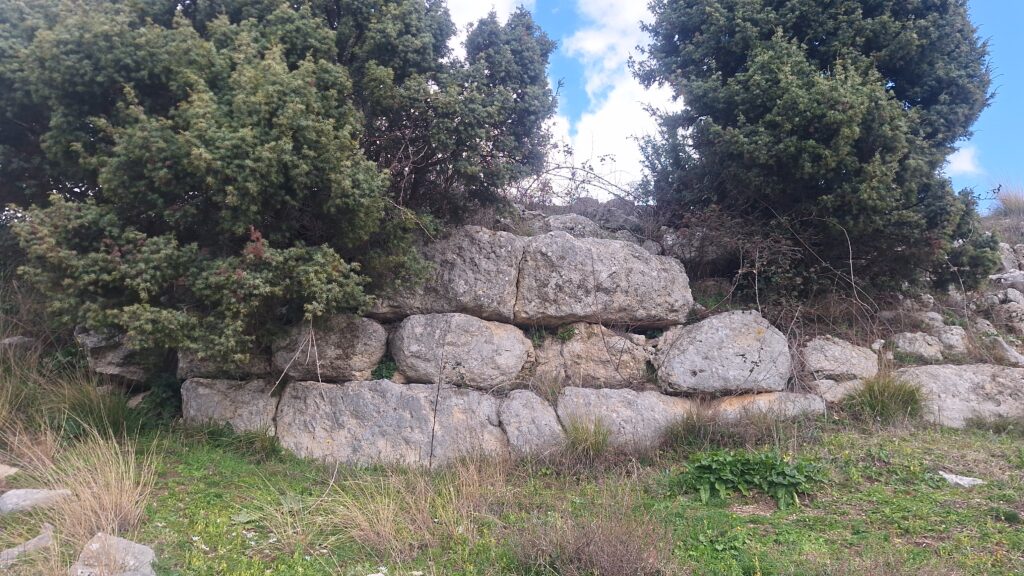
The hill on which the castle stands is naturally well protected. Its northern side falls sharply into an impassable rocky abyss, while the southern side was enclosed by a curved defensive wall approximately 370 meters long, surrounding an area of about 1.8 hectares.
Inside the fortification, the terrain is largely rocky and eroded. Only terraces created along the inner side of the walls and a terraced section of the southeastern slope were suitable for habitation.
At first glance, few traces of ancient structures appear visible. Yet closer observation reveals a remarkable archaeological story: the walls preserve four distinct construction phases spanning nearly 1,200 years, from the 6th century BC until the 6th century AD.
The First Construction Phase (7th–6th Century BC)
The earliest phase of construction is best preserved in the western corner of the fortification, where a bastion measuring about 7.20 × 6.70 meters survives, although only its outer rows remain visible.
This bastion is connected to a contemporary wall segment preserved up to 3 meters high, 2.30 meters wide, and about 60 meters long. The wall was built using large limestone blocks arranged in irregular rows, with quadrangular and polygonal shapes roughly hammered along their horizontal faces. Smaller stones were used to fill the gaps between them.
Fragments of this earliest wall are also visible on the southeastern side of the fortress near the entrance, where they were partially covered by later reconstructions.
The gateway of this phase is positioned at a bend in the wall—an architectural model also known from proto-urban fortifications of the 7th–5th centuries BC, such as those at Mashkjeza of Cakran and Belshova.
Archaeological finds discovered at the site—including painted proto-urban pottery and archaic ceramics imported from Dyrrhachium dating to the 7th–6th centuries BC—belong to this phase.
Dorëzi Castle therefore belongs to a group of fortified settlements that mark the beginning of the urbanization process in the territory known in antiquity as the Koinon of the Parthinians. Contemporary proto-urban centers include the fortifications of Zgërdhesh Castle, Berat, and Belsh, which preceded the formation of fully developed Parthinian cities in the 4th century BC.
The Second Construction Phase (Late 5th Century BC)
The second phase is represented by a wall segment about 30 meters long located in the central part of the fortification.
Its facade consists of carefully worked trapezoidal and polygonal blocks measuring 0.65–0.80 meters in height, arranged in stepped rows. The wall is approximately 2.70 meters wide and contains smaller stones between the two outer faces, reinforced by transverse connecting walls.
Another section about 14.5 meters long represents a more advanced stage of the same phase, showing better alignment of the blocks and smoother finishing of their outer surfaces.
In terms of technique, these walls resemble the late 5th-century BC fortifications of the archaeological sites of Butrint Archaeological Site, Amantia, and Klos. The construction also uses transverse blocks (diatones), which connect the outer facade with the interior stone filling.
During this period, Dorëzi belonged to the earliest Illyrian settlements with an urban character located in the hinterland of the Greek colony of Dyrrhachion.
The Third Construction Phase (3rd Century BC)
The third construction phase involved a complete reconstruction of the southeastern section of the fortification.
The new wall, about 2.50 meters wide, was built using the emplekton technique: two outer stone faces with a core of smaller stones connected by transverse walls placed at intervals of about 2.30 meters.
The facade appears almost isodomic, with blocks of equal height (about 0.60 meters) similar to those seen in the walls of Persqop Castle and Zgërdhesh Castle.
Two gateways located in the southeastern corner also belong to this phase. The main entrance forms a corridor 3.15 meters wide and 4.40 meters long between two quadrangular towers measuring approximately 4 × 3.80 meters.
This defensive design suggests construction during the 3rd century BC, when the Illyrian kings Monunius and Mytilus consolidated their authority over the territory of the Parthinians and established control over Dyrrhachion.
During this time, Dorëzi Castle likely functioned as a strategic defensive point controlling trade routes crossing the region.
Pottery fragments found on the surface do not date later than the 1st century BC, suggesting that the settlement was abandoned after the Roman conquest and the reorganization of regional transportation along the new Via Egnatia.
The Fourth Construction Phase (6th Century AD)
A final construction phase is visible in several reconstructed sections of the fortification walls. These repairs filled cracks created during the long abandonment of the site.
The reconstruction technique uses lime mortar to bind medium and small stones, a method also known from fortifications such as Tujani Castle and other Late Antique fortresses in the region.
Coin finds and characteristic pottery date these reconstructions to the reign of the Byzantine emperor Justinian I (527–565 AD). During his rule, a large defensive network of fortresses was established throughout the Balkans to protect the region from Slavic incursions in the mid-6th century.
Conclusion
Dorëzi Castle – A Forgotten Fortress Above the Ancient Roads of Illyria
Hidden among the hills southwest of Tirana, the ancient Castle of Dorëzi stands on a dramatic rocky ridge overlooking the valleys of the Erzen and Peza rivers. Today the site is quiet and almost unknown to visitors, yet its stone walls preserve the story of more than a millennium of history, from the early Illyrian world to the Byzantine Empire.
Archaeological research shows that the fortress controlled one of the natural routes connecting the ancient Adriatic city of Dyrrhachium with the interior of the Balkans. Long before the construction of the Roman Via Egnatia, this corridor through the Erzen and Shkumbin valleys served as an important passage linking the Adriatic coast with Macedonia.
The strategic position of Dorëzi allowed its inhabitants to monitor movement along this route while enjoying the protection of steep natural cliffs. Over centuries, its fortification walls were rebuilt and strengthened several times, leaving visible traces of four different construction phases that span nearly 1,200 years, from the 6th century BC until the time of the Byzantine emperor Justinian I.
Even earlier traditions suggest that the hill may have been inhabited as far back as the Bronze Age, making Dorëzi one of the oldest known fortified settlements in the wider region of Tirana.
This Article is published in the framework of the project #TiranaHeritageRoutes, nje ide e DMO ALBANIA, zbatuar në kuadër te programit Boost Balkans, zbatuar nga Alda Balkans dhe financuar nga AFD (Agence Française de Développement)
Other News to Read
Discover Dorëzi Castle- the oldest urban civilisation in Tirana
Discover Dorëzi Castle- the oldest urban civilisation in the Tirana Region
What to do in March 2026 in Tirana
Welcome Spring, the best season to Visit Tirana. March is the first month of spring, and the flowers…
Ndroq Castle – The rock that saved a Byzantine Emperor
Ndroq Castle – The rock that saved a Byzantine Emperor – 1081. The story by Ana Khomena
The Ancient Origins of the Name Tirana- A toponymic and archaeological story
The Ancient Origins of the Name Tirana- A toponymic and archaeological story